1. INTRODUCTION
A geological map is a special-purpose map made to show geological features. Rock units or geologic strata are shown by color or symbols to indicate where they are exposed at the surface. Geological maps are usually superimposed over a topographic map with the addition of a color mask with letter symbols to represent the kind of geologic unit. The color mask denotes the exposure of the immediate bedrock, even if obscured by soil or other cover. Each area of color denotes a geologic unit or particular rock. However, in areas where the bedrock is overlain by a significantly thick unconsolidated burden of till, terrace sediments, loess deposits, or other important feature, these are shown instead.
Geological maps are prepared in all countries by governmental offices; usually called “Geological Survey” a good example is the Geological Survey of the United States and Iraq Geological Survey (GEOSURV). However, universities, oil companies, and special research centers may contribute in preparations and compilation of the geological maps, especially those of large-scale and special purpose geological maps. Moreover, some very special companies can perform geological mapping in some countries in the form of contracts with the state geological mapping office.
B efore 1991, Iraq Geological Survey was the responsible governmental office about carrying geological mapping for the whole country including the Kurdistan Region. However, after 1991, special offices were established in Erbil and Sulaimani to perform the task of the geological mapping. After 2003, geological mapping in the Kurdistan Region was the task of five offices located in Erbil, Sulaimani, Duhok, Koya, and Darbendikhan, which are linked to the Ministry of Natural Resources (MNR).
2. GEOLOGICAL MAPS IN THE KURDISTAN REGION
To delineate the status of the geological maps in the Kurdistan Region, the compiled geological maps at different scales are mentioned below.
2.1. Historical Review
The history of the present geological maps in Iraq including the Kurdistan Region of different scales is reviewed hereinafter.
2.1.1. Geological map of McFadden
It is the first geological map of Iraq at a scale of 1: 25,00,000 was compiled by the Governmental Geologist McFadden in 1937. The map, which has large similarity with the most recent compiled map of Iraq at a scale of 1:10,00,000 (Sissakian and Fouad, 2012), was compiled in the Ministry of Municipalities, Directorate of Geology. This map shows only the age of the exposed rocks over the whole Iraqi territory including the Kurdistan Region. It is saved in the archive of GEOSURV.
2.1.2. Kurdistan series of geological maps
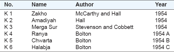
The series includes 6 sheets (K1–K6) at scale of 1:1,00,000 compiled by the Site Investigation Co. during early fifties of the past century. The series covers a zone along the Iraqi-Turkish and partly Iranian borders from Zakho to Halabja (Fig. 1). The reports are called K-Series referring to Kurdistan and are saved in the archive of GEOSURV. The titles of the six reports with the name of the authors and publication dates are shown in Table 1.
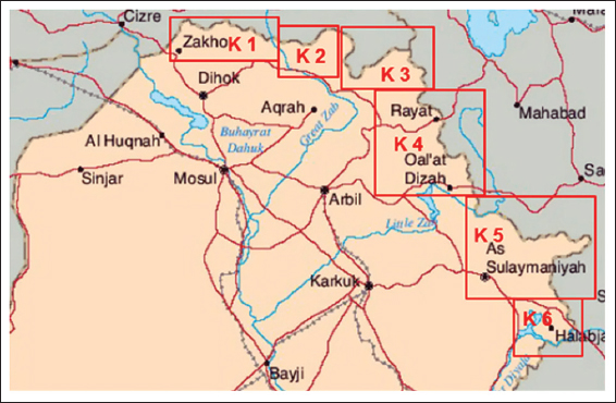
Figure 1. Index of the K-series reports
Table 1. Index of the K-Series of geological maps (1: 1,00,000 scale)
These geological maps are the first geological maps which represent not only the details of the stratigraphy of the exposed rocks but also all the existing mineral showings in their coverage areas. Therefore, they were used as base maps and reports during execution of the geological mapping not only in the Kurdistan Region but also in the whole Iraqi territory. Moreover, all performed studies concerning oil discoveries have used the data furnished in those maps and reports too.
2.1.3. Geological map of Bolton
It is the first officially printed and published geological map of Iraq at the scale of 1: 10,00,000, and it was compiled by Bolton (1960). It depends on the executed geological mapping in different parts of Iraq and the available geological maps, especially the “K-Series of Geological Maps” at the scale of 1:1,00,000. The map was printed in Johannesburg, South Africa, and is saved in the archive of GEOSURV.
2.1.4. Geological maps of soviet team
During 1959–1962, a Soviet Team executed geological mapping for very small parts in the extreme northern and northeastern parts of Kurdistan. The mapping was at a scale of 1:20,000 and was forwarded for Mineral Investigation purposes, especially in Penjween area (Sulaimaniyah Governorate) and Duri Sargoza area, northeast of Zakho (Duhok Governorate). The executed geological mapping did not show positive mineral wealth in the covered areas. The maps are saved in the archive of GEOSURV.
2.1.5. Geological maps of czechoslovakian team
During the period 1975–1976, a Czechoslovakian Team with the collaboration of Iraq Geological Survey executed geological mapping at a scale of 1:1,00,000 for an area extending from north of Halabja to northeast of Chwarta. The geological maps presented the details of the exposed rocks with some mineral potentials. The maps are saved in the archive of GEOSURV.
2.1.6. Iraq geological survey (GEOSURV) geological maps
GEOSURV started performing systematic geological mapping for the whole Iraqi territory including Kurdistan Region in 1972. Two geological mapping groups covered two different areas during 1972–1974. The first one is Mawat area, north of Sulaimani city with high copper potential, whereas the second one is in Kani Masi area, NE of Amadiya town with high potential of iron, lead, and zinc. Later on, the systematic geological mapping was interrupted due to political unrest, and GEOSURV performed geological mapping in different parts of the Kurdistan Region during 1978–1980 and 1988–1991. However, the most potential areas of mineral wealth were not covered because they occur along the extreme northern and North Eastern parts of the Kurdistan Region.
After 2003, GEOSURV performed geological mapping training program to the geologists of MNR, Kurdistan Region during 2005–2009. During this period, small parts of the northeast of Erbil city and northwest of Sulaimani city were covered by detailed geological maps at a scale of 1:20,000. Therefore, large parts of the Kurdistan Region remained uncovered by detailed geological maps. However, Sissakian and Fouad (2012) performed checking and updating of the available geological mapping during 2006–2012. This was escorted by the staff of University of Sulaimani, Kurdistan Institution of Strategic Studies and Projects, and University of Salahideen. Although considerable areas were checked and updated (Fig. 2), still large parts lack detailed geological maps in the Kurdistan Region.
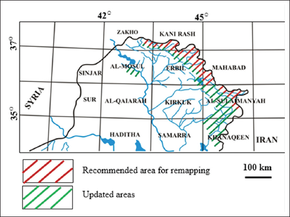
Figure 2. Index map showing the areas covered by updated maps and recommended areas for remapping (after Sissakian and Fouad, 2012)
2.2. Available Published Geological Maps in the Kurdistan Region
The only available published geological maps in the Kurdistan Region are in two scales, 1:2,50,000 and 1:10,00,000, both are compiled and published by GEOSURV.
2.2.1. Geological maps at a scale of 1:2,50,000
The following geological maps of 1:2,50,000 quadrangles cover the Kurdistan Region. Some of the quadrangle sheets cover the following parts of the region: Zakho Quadrangle (Al-Musawi et al., 2007), Kani Rash (Fouad, 2007), Sinjar (Sissakian, 1995), Al-Mosul (Sissakian, 2013), Erbil and Mahabad (Sissakian and Fouad, 2014a), Kirkuk (Sissakian and Fouad, 2014c), Sulaimaniyah (Sissakian and Fouad, 2014b), Khanaqin (Barwary and Slewa, 2014a), and Mandili (Barwary and Slew, 2014b).
2.2.2. Geological maps at a scale of 1: 10,00,000
GEOSURV printed and published four editions of the Geological Map of Iraq at a scale of 1:10,00,000, during 1986, 1990, 2000, and 2012. The four version covers the whole area of the Kurdistan Region. The four versions of the geological maps of Iraq are compiled by Jassim et al. (1986 and 1999), and Sissakian and Fouad (2012).
2.3. Available Unpublished Geological Maps in the Kurdistan Region
Geological maps at a scale of 1:1,00,000 and 1:20,000 are available but are not published.
2.3.1. Geological maps at a scale of 1:1,00,000
GEOSURV compiled this series of geological map for the whole Iraqi territory including the Kurdistan Region. The series includes 209 quadrangles. Nevertheless, these maps are not published because the base topographic maps are considered as military maps.
2.3.2. Geological maps at a scale of 1:20,000
GEOSURV used topographic maps at a scale of 1:20,000 as base maps during performing of geological mapping in different parts of the Kurdistan Region. These maps are saved in the archive of GEOSURV. However, not the whole part of the region is covered by mapping as it is mentioned above. Vast areas along the extreme northern and northeastern parts of the region with a depth vary from 10 to 30 km from the borders with Turkey and Iran lack geological maps. It is worth mentioning that those areas are the most promising as the mineral wealth in the Kurdistan Region is concerned.
3. CONCLUSIONS
From this very brief review about the geological maps in the Kurdistan Region, it can be concluded that large parts of the Iraqi Kurdistan Region lack detailed geological maps at a scale of 1:20,000, which are the most important and valuable maps. Accordingly, no true estimate to the mineral wealth can be done in the Kurdistan Region. Moreover, no relevant decisions and/or plans can be performed by the decision-makers as different geological aspects are concerned, such as urban, industrial, agricultural, transportation, and irrigation planning.
4. RECOMMENDATIONS
It is highly recommended that the concerned authorities, MNR, start planning to cover the whole area of the Kurdistan Region by geological maps at a scale of 1:20,000 by performing geological mapping. Since the already existing geological staff in MNR geological offices lack the geological mapping experience, therefore, it is highly recommended to start the geological mapping activities by means of a contract with well-known geological survey offices in any relevant country.